
Home · World · Oct 9 archive
Isaias Intensifies into Category 2 Hurricane, Threatening Gulf Coast
Confirmed
In Short: Isaias, currently a Category 2 hurricane with maximum sustained winds of 100 mph, is moving northeast at 12 mph, about 325 miles south of the Mississippi River's mouth, according to the National Hurricane Center.
Michael Brennan, director of the National Hurricane Center in Miami, warned, "We are expecting Isaias to be a dangerous hurricane when it makes landfall."
The storm is expected to jog east-northeast for another day before turning sharply toward the northern Gulf Coast, further intensifying. As of Thursday, Isaias had maximum sustained winds of 105 mph, surpassing the 96 mph threshold for a Category 2 storm.
Coastal communities are preparing for the worst. In Alabama, officials encouraged voluntary evacuations on Dauphin Island, a 15-mile barrier island off the coast, particularly on its western section, which is vulnerable to storm surge.
Boat owner Tony Rice in Bayou La Batre, Alabama, is securing his boat by hauling doors onto it as a precautionary measure.
Oil and gas producers have shut down a significant share of offshore production in the Gulf, which accounts for almost 15 percent of crude pumped annually in the U.S. As of Thursday, about 63 percent of the oil production in the region had been temporarily halted, taking nearly 1.3 million barrels a day off the market.
Isaias is expected to bring gusty winds, heavy rain, and the potential for tornadoes to the Carolinas over the weekend. In Charlotte, widespread rainfall is anticipated on Saturday as the storm moves farther north.
Governors across the Gulf Coast are urging residents to prepare for potential storm damage and prolonged power outages. Florida's Governor Ron DeSantis advised residents in the Panhandle to heed evacuation orders and prepare for power outages and flooding.
The National Weather Service warned communities from Ocean Springs, Mississippi, to Gulf County, Florida, to prepare for the possibility of long-duration power outages.
The storm's progression into a hurricane on Wednesday marked the latest date in 121 years for the Atlantic season's first hurricane to develop, just missing a record set on Oct. 8, 1905, according to National Oceanic and Atmospheric Administration data.
Isaias is expected to remain a dangerous hurricane through landfall, with gusty winds expected well inland after landfall given the anticipated expansion of the wind field and accelerating forward speed of the storm.
The National Hurricane Center reports that 121 of the Gulf’s 371 manned oil platforms had been evacuated.
What this adds
The storm's intensity and path have been closely monitored by multiple outlets, with some reporting slightly different distances from the Mississippi River's mouth. The National Hurricane Center's forecast shows the storm strengthening into Hurricane Isaias, with landfall currently estimated to be sometime late Friday or early Saturday between Gulf Shores, Alabama, and Pensacola, Florida.
Background
The National Hurricane Center’s forecast shows the storm strengthening into Hurricane Isaias, with landfall currently estimated to be sometime late Friday or early Saturday between Gulf Shores, Alabama, and Pensacola, Florida.
Texas A&M University researchers are collaborating with local, state, and federal emergency partners to map storm-surge risks, identify vulnerable communities, and plan evacuation routes for Gulf Coast hurricanes.
The Gulf Coast of the United States, also known as the Gulf South or the South Coast, is the coastline along the Southern United States where they meet the Gulf of Mexico. The coastal states that have a shoreline on the Gulf of Mexico are Texas, Louisiana, Mississippi, Alabama, and Florida, and these are known as the Gulf States.
What's confirmed
- “We are expecting Isaias to be a dangerous hurricane when it makes landfall,” said Michael Brennan, director of the National Hurricane Center in Miami.
- He added: “Today is the day to prepare and get ready and be in your safe place by tomorrow as conditions will rapidly deteriorate along the northern Gulf Coast as Isaias approaches.” Isaias had maximum sustained winds of 100 mph (155 kph), according to the hurricane center, surpassing the 96 mph (154 kph) threshold for a Category 2 storm.
- Isaias was headed northeast at 12 mph (19 kph) and was centered about 325 miles (525 kilometers) south of the mouth of the Mississippi River.
- On Dauphin Island, a 15-mile (24-kilometer) barrier island off the Alabama coast, officials encouraged voluntary evacuations, particularly on its popular western section, which is vulnerable to storm surge.
- It said 121 of the Gulf’s 371 manned oil platforms had been evacuated.
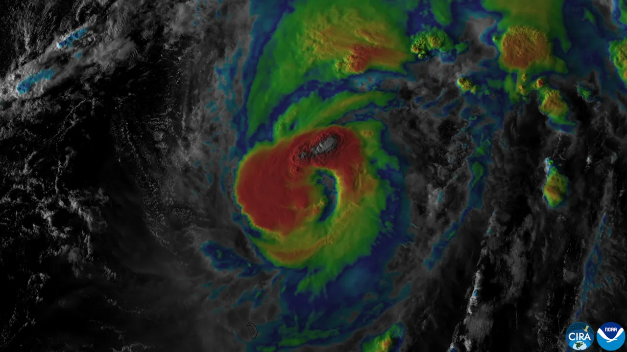
- This satellite image from the National Oceanic and Atmospheric Administration shows Tropical Storm Isaias off the eastern coast of Mexico on Wednesday, Oct. 7, 2026.
- EDT, Wednesday, Oct. 7, 2026, shows Tropical Storm Simon, bottom center, in the Pacific Ocean, off the southwestern coast of Mexico, and Tropical Storm Isaias, upper right, east of Mexico in the Gulf of Mexico.
What's still developing
- Millions of Americans along the Gulf Coast are on high alert due to life-threatening conditions as Hurricane Isaias gains power and moves closer to land.
- WATCH NOW: The latest WCCB WeatherWise forecast and what Isaias could bring to the Carolinas Preparations underway Coastal communities moved quickly to prepare, as Alabama Gov. Kay Ivey ordered non-residents to immediately evacuate Gulf Shores, Orange Beach and Dauphin Island.
- Rapid intensification is when a storm’s sustained winds increase by at least 35 mph in 24 hours or less, a feat more hurricanes are pulling off as Earth and its oceans warm from fossil fuel pollution.
- The Atlantic is on pace for its quietest season since 2013, when only two hurricanes formed.
Sources
- Arabnewslink
- Bozeman Daily Chroniclelink
- Decatur Dailylink
- PBSlink
- WBTVlink
- WCCB Charlottelink
- news8000.comlink
- Foxweatherlink
- CBS Newslink
- News4Jaxlink
- Centraloregondailylink
- Wsfalink
- Scrippsnewslink
- WarpBeat — background on Isaias Intensifies, Gulf Coast Braces for Hurricane Landfall link
- WarpBeat — background on Texas A&M Researchers Aid Gulf Coast Communities in Hurricane Planning link
- Wikipedia — background on Gulf Coast of the United States link
- FOX Weather — video link