
Home · World · Oct 9 archive
Magnitude 7.7 Earthquake Strikes Panama, and the Tsunami Threat Has Passed
Confirmed
In Short: The U.S. Geological Survey reviewed the quake at magnitude 7.7, and the Pacific center's final message says the tsunami threat has passed.
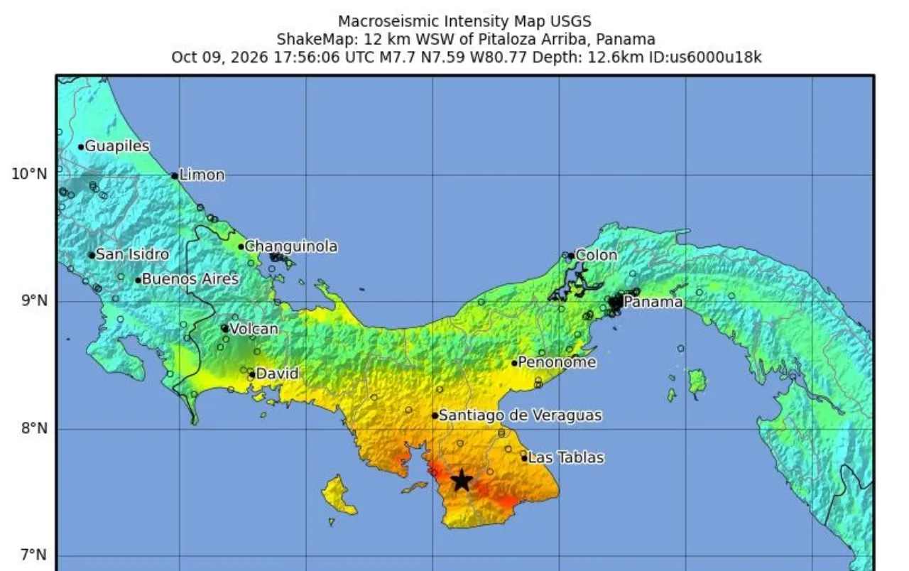
The U.S. Geological Survey reviewed a magnitude 7.7 earthquake 12 km west-southwest of Pitaloza Arriba, Panama, at 12:56 PM local time, which was 1:56 PM Eastern time. The Pacific Tsunami Warning Center's final message, at 1939 UTC, said the tsunami threat from this earthquake has passed. The first automatic estimate was magnitude 8.0, and the tsunami centers used a preliminary magnitude of 7.6.
The center's 1851 UTC message had forecast waves of 1 to 3 meters above the tide along some coasts of Panama, and waves of less than 0.3 meters for Hawaii, Costa Rica, Colombia, Ecuador, Mexico, Peru, Chile, El Salvador, Guatemala and Nicaragua. It used a preliminary magnitude of 7.6 and a depth of 33 km. The 1939 UTC message said that forecast was unchanged and that there is no longer a tsunami threat. It said minor sea level fluctuations may occur for a few hours in some coastal areas near the earthquake, and that no action is required beyond normal caution near the sea.
The U.S. National Tsunami Warning Center said there is no tsunami danger for the U.S. West Coast, British Columbia, or Alaska, though some of those coasts may see non-damaging sea level changes. That center used a preliminary magnitude of 7.6, a depth of 6 miles, and called the statement final unless more information arrived. A separate Hawaii statement from the Pacific Tsunami Warning Center said there is no tsunami threat to Hawaii and that a destructive Pacific-wide tsunami is not expected.
The Pacific center's first message, at 1801 UTC, had used a preliminary magnitude of 8.0 and said hazardous waves were possible within three hours along some coasts of Panama, Colombia, Costa Rica, Ecuador, Peru, Nicaragua, Guatemala, El Salvador and Mexico. Later messages replaced that wider warning, and the final message said the threat had passed.
The center said the first wave may not be the largest, and that a tsunami is a series of waves that can arrive five minutes to an hour apart. Its 1851 UTC message listed estimated arrivals of 1820 UTC at Punta Mala, 1831 UTC at Puerto Pina, 1840 UTC at Punta Burica, and 2041 UTC at Balboa Heights. The final message, at 1939 UTC, came before that Balboa Heights forecast time. The bulletins did not report a measured wave at those points.
Fox Weather worded the Panama coast forecast as 3 to 9 feet, its rendering of the 1 to 3 meter line, and said Ecuador could see waves up to 3 feet while other coasts would see less than 1 foot. Costa Rica's National Tsunami Monitoring System, SINAMOT, said there is no tsunami threat to Costa Rica.
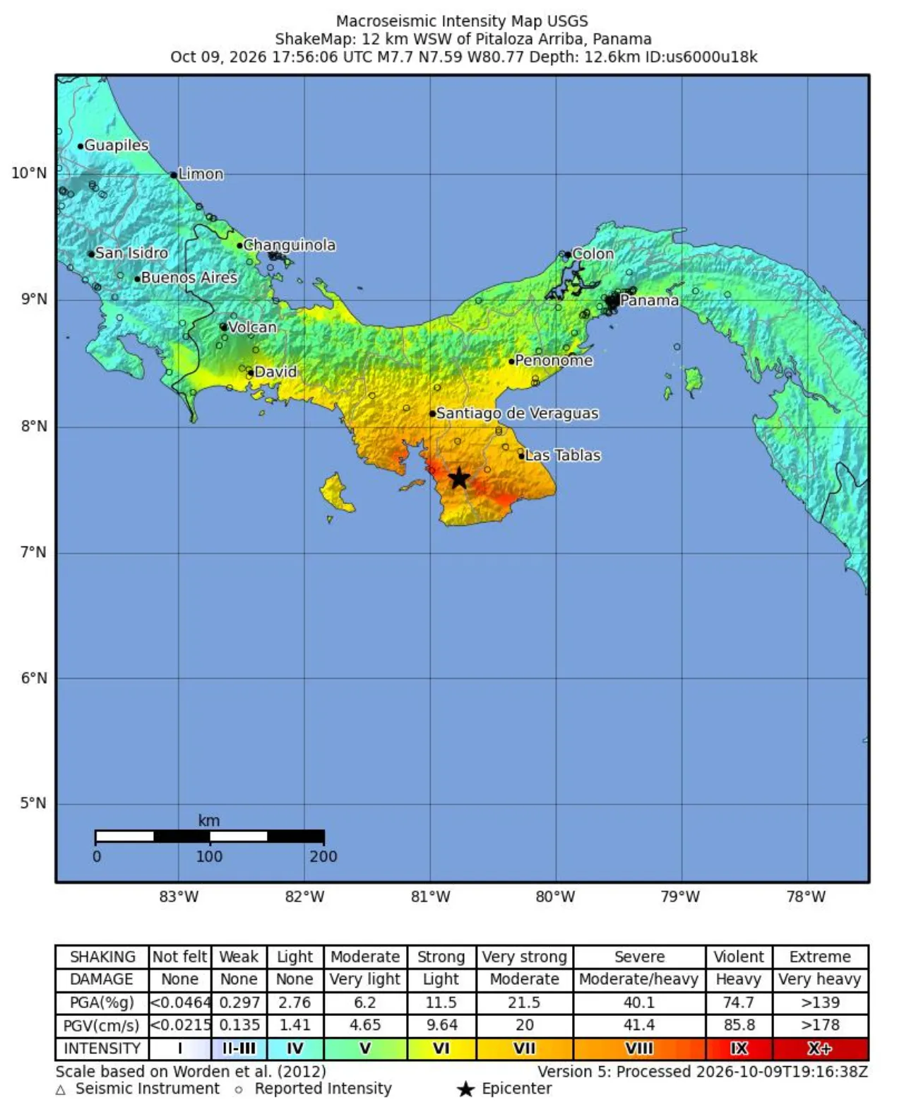
USGS reviewed the origin as 17:56:06 UTC on 9 October 2026, at 7.587 degrees north and 80.769 degrees west, with a depth of 12.6 km. Depth figures differ by product: the reviewed depth is 12.6 km, the tsunami center's preliminary depth was 33 km, and the National Tsunami Warning Center used 6 miles. Early reports placed the spot about 10 km, or 6.2 miles, west-southwest of Pitaloza Arriba.
The current USGS PAGER population model for Panama estimates about 3,704 people at MMI IX, about 38,032 at MMI VIII, about 443,815 at MMI VII, about 736,710 at MMI VI, and about 3,253,648 at MMI V. Did You Feel It showed 519 reports, with a maximum community intensity of 8.5. The ShakeMap's highest estimated intensity was 8.7.
The current USGS city list estimated intensity 8.4 at Tonosi, 8.0 at Llano de Piedra, 7.6 at Macaracas, and 7.5 at Pedasi. On that same list, Las Tablas and Ocu were at 7.2, Guarare at 7.0, Santiago at 6.9, Chitre at 6.8, and Aguadulce at 6.3. The listed populations are 2,257 at Tonosi, 1,737 at Llano de Piedra, 2,890 at Macaracas, 2,410 at Pedasi, 11,358 at Las Tablas, 7,006 at Ocu, 9,255 at Guarare, 45,955 at Santiago, 46,191 at Chitre, and 51,668 at Aguadulce.
The USGS PAGER alert is red for economic losses, estimating losses at 0 to 9 percent of Panama's GDP, and yellow for fatalities, meaning some casualties are possible. The ground-failure model estimated a landslide population exposure of 469 and a liquefaction population exposure of 26,763. No confirmed casualty count was in these reports.
CNN reported that President José Raúl Mulino called for calm and instructed the minister of government to provide information, and that local media were reporting structural damage. Reuters witnesses said the quake was felt in Panama City and in San José, Costa Rica. Noticias Caracol said people in Cartagena, Colombia, also reported feeling it. Rosendo Domínguez, 60, of Herrera province, told the Associated Press the quake knocked things over in the kitchen, that he was unhurt, and that everyone outside was scared.
Reuters reported that no damage was initially reported and that the Panama Canal Authority said the waterway was operating normally. An earlier Spanish-language Reuters report said local images showed fallen roofs at universities and people leaving large buildings, while a preliminary check found the canal still operating. The Hindustan Times reported that Panama's Civil Protection agency was assessing possible damage near the epicenter and that further details were not immediately available.
By 19:40 UTC, USGS had reviewed six later earthquakes of magnitude 4.8 or greater near the main shock: magnitude 5.5 about 3 km southwest of Bajo Corral 26 minutes later, magnitude 5.8 about 1 km south of El Cacao 42 minutes later, magnitude 5.0 about 19 km south of Leones Arriba 51 minutes later, magnitude 5.0 about 18 km south of Los Asientos 54 minutes later, magnitude 5.0 about 14 km southeast of Río Grande 69 minutes later, and magnitude 4.8 about 14 km south-southwest of Tebario 81 minutes later. USGS said more aftershocks, some potentially with strong shaking, may follow.
Reuters placed the epicenter near the rural community of La Pitaloza, in a sparsely populated area close to Panama's Pacific coast, and said television footage showed people evacuating buildings.
What this adds
The 8.0, 7.6, and 7.7 figures are different products, not one revised number. Fox Weather's 3-to-9-foot line is that outlet's rendering of the 1-to-3-meter forecast, while its Ecuador line of up to 3 feet does not match the 1851 UTC bulletin's under 0.3 meters. The final message did not change those amplitudes. It said the threat had passed.
What's confirmed
- USGS reviewed the main shock at magnitude 7.7, 12 km west-southwest of Pitaloza Arriba, depth 12.6 km, at 12:56 PM Panama time.
- The Pacific Tsunami Warning Center's final message, at 1939 UTC, says the tsunami threat has passed. The previous bulletin had forecast waves of 1 to 3 meters on some Panama coasts and under 0.3 meters elsewhere, including Hawaii.
- There is no tsunami danger for the U.S. West Coast, British Columbia, or Alaska, and no tsunami threat to Hawaii.
- The Panama Canal Authority said the waterway was operating normally. No confirmed casualty count was in these reports.
What's still developing
- Damage reports do not yet agree. The Pacific center said minor sea level fluctuations may continue for a few hours near the earthquake, and that its 1939 UTC message is final unless new information arrives.
Sources
- U.S. Geological Survey — Reviewed origin, ShakeMap, PAGER, and aftershocks link
- Pacific Tsunami Warning Center — Message 4, 1939 UTC, final threat message link
- Pacific Tsunami Warning Center — Message 3, 1851 UTC, the 1 to 3 meter forecast link
- National Tsunami Warning Center — Statement 2 for the U.S. West Coast, British Columbia, and Alaska link
- Pacific Tsunami Warning Center — Hawaii statement 2 link
- CNNlink
- Reuters — English report link
- Reuters — Earlier Spanish-language report link
- Fox Weatherlink
- Hindustan Times — Carries the Associated Press interview with Rosendo Domínguez link
- SINAMOT — Costa Rica tsunami bulletin link
- Noticias Caracol — Report that the quake was felt in Cartagena link