
Home · World · Sep 29 archive
NASA Captures Rare Image of Pileus Cloud Over Wildfire
Confirmed
In Short: NASA scientists have captured rare observations of an ephemeral pileus cloud hovering over a smoke-infused cloud that rose above a wildfire in Montana.
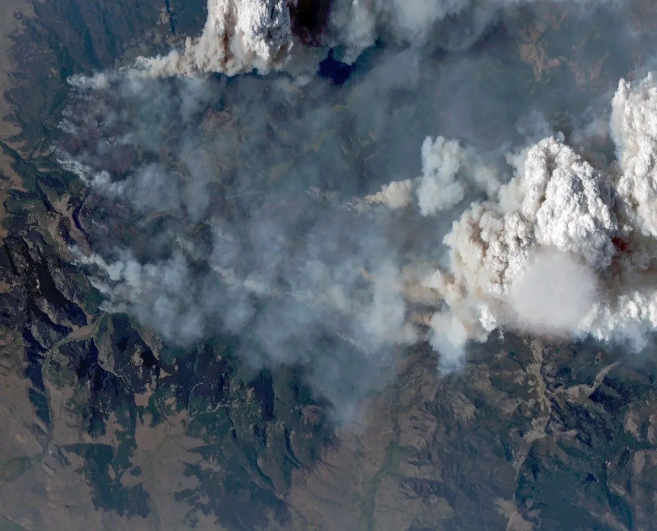
NASA scientists have captured rare observations of an ephemeral pileus cloud hovering over a smoke-infused cloud that rose above a wildfire in Montana.
The process is similar to how air forced over a mountain can produce clouds, explained Neil Lareau, deputy project investigator for INSPYRE's project.
At the time of the image, the fire was rapidly advancing up the western side of Mount Comet as winds aligned with the drainage channels leading up the mountain.
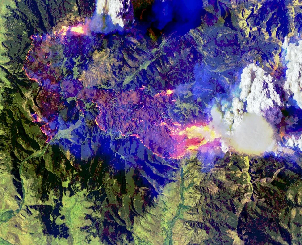
The image above shows the cloud in four of the 50 channels, or bands, measured by MASTER.
During NASA's CRYSTAL-FACE mission in Honduras in 2002, researchers reported the presence of thin cirrus clouds in the tropopause above thunderstorms, likely products of pileus clouds.
One of the most striking images captured by astronauts and published by NASA Earth Observatory is a photograph of a pileus cloud cloaking the top of a volcanic plume rising from the Sarychev volcano after an eruption in 2009.
In summer 2026, scientists took to the air to intercept and study the towering, smoke-infused clouds that wildland fires sometimes create.
During an August 11 flight over the Sand Creek fire in Montana, they observed an ephemeral pileus cloud hovering atop one of the towering fire clouds.
Smooth, veil-like pileus clouds are well-known to atmospheric scientists and cloud lovers and are regarded as signs of especially vigorous convection.
Named after the Latin for “cap,” pileus clouds typically form when rising columns of air collide with a sufficiently moist layer of air aloft.
Over the Sand Creek fire, a fast-rising updraft heated by the fire displaced air vertically and forced a horizontal layer of moister air sitting above it upward.
As the displaced air was pushed upward, it cooled, and its water vapor condensed into a pileus cloud.
What this adds
The observations provide new insights into the interaction between pileus clouds and pyrocumulus clouds formed by wildfires.
The detailed imagery captured by MASTER offers a unique opportunity to study these rare atmospheric phenomena.
What's confirmed
- NASA scientists have captured rare observations of an ephemeral pileus cloud hovering over a smoke-infused cloud that rose above a wildfire in Montana.
- The process is similar to how air forced over a mountain can produce clouds, explained Neil Lareau, deputy project investigator for INSPYRE's project.
- At the time of the image, the fire was rapidly advancing up the western side of Mount Comet as winds aligned with the drainage channels leading up the mountain.
- The image above shows the cloud in four of the 50 channels, or bands, measured by MASTER.
- During NASA's CRYSTAL-FACE mission in Honduras in 2002, researchers reported the presence of thin cirrus clouds in the tropopause above thunderstorms, likely products of pileus clouds.
- One of the most striking images captured by astronauts and published by NASA Earth Observatory is a photograph of a pileus cloud cloaking the top of a volcanic plume rising from the Sarychev volcano after an eruption in 2009.
- In summer 2026, scientists took to the air to intercept and study the towering, smoke-infused clouds that wildland fires sometimes create.
- During an August 11 flight over the Sand Creek fire in Montana, they observed an ephemeral pileus cloud hovering atop one of the towering fire clouds.
- Smooth, veil-like pileus clouds are well-known to atmospheric scientists and cloud lovers and are regarded as signs of especially vigorous convection.
- Named after the Latin for “cap,” pileus clouds typically form when rising columns of air collide with a sufficiently moist layer of air aloft.
- Over the Sand Creek fire, a fast-rising updraft heated by the fire displaced air vertically and forced a horizontal layer of moister air sitting above it upward.
- As the displaced air was pushed upward, it cooled, and its water vapor condensed into a pileus cloud.
What's still developing
- "The whole scene is amazing," he said, noting that the science team was fortunate that MASTER's visible channels captured the rapidly developing pyrocumulus and pileus cloud, its infrared channels captured the fire's extreme surface behavior, and downward-pointing radars on the airplane studied the cloud structure.
- NASA aircraft are sampling smoke lofted high into the atmosphere by one of the most formidable cloud types in the… A low-lying cloud layer brought autumn ambience to western Washington and Oregon, while mountainous areas near the coast remained above… Wildland fires in early August 2026 pushed air quality to unhealthy levels, destroyed hundreds of structures, and triggered mandatory evacuations… Subscribe to the Earth Observatory and get the Earth in your inbox.
- But researchers rarely observe a pileus cloud interacting with a fire cloud—known as a pyrocumulus (pyroCu)—in as much detail as they did on this flight, part of NASA’s INSPYRE (Injected Smoke and Pyrocumulonimbus Experiment) campaign.