
Home · World · Sep 28 archive
Hurricane Polo Threatens Baja California with Life-Threatening Flooding
Confirmed
In Short: Hurricane Polo, a Category 3 storm, is expected to make landfall in Baja California Sur, Mexico, bringing dangerous winds and flooding. The storm is poised to become the first known major hurricane to hit the western coast of the Baja California peninsula.
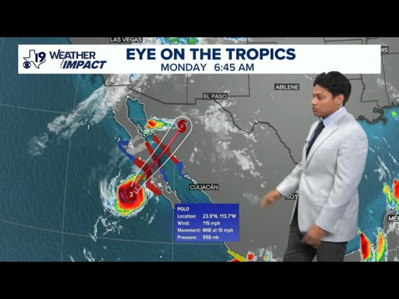
According to the U.S. National Hurricane Center, Polo is expected to strike Baja California Sur with near-major hurricane strength, with maximum sustained winds of 115 mph as of Monday afternoon.
The storm's impact is expected to extend beyond Baja California Sur, with flash floods and heavy rainfall forecast for the Four Corners Region and the Central Plains, potentially affecting major cities such as Phoenix, Albuquerque, Dallas, Oklahoma City, and Omaha.
The National Civil Protection Coordination's Laura Velázquez warned that Polo is expected to make landfall in the municipality of Comondú between 4 p.m. and 6 p.m. local time on Monday, bringing the risk of destructive winds, torrential rains, flooding, and dangerous surf.
Shelters across the state remained open, and officials were coordinating with local and national authorities to prepare for additional impacts of the hurricane. The Mexican navy had gathered personnel and humanitarian aid in the ports of Guaymas and Mazatlan, and deployed three vessels to ship aid to coastal communities isolated by the storm.
Forecasters warned that Polo would likely weaken as it tracks inland toward mainland Mexico but would still be powerful enough to be considered a hurricane by the time of its landfall there, with winds of at least 74 mph.
Conditions are deteriorating over portions of Baja California as life-threatening winds and flash floods are expected to occur soon.
The Pacific has been unusually active, with storm activity running above average during what is already the peak of hurricane season, consistent with El Niño years.
The hurricane center said Rachel had maximum sustained winds of 40 mph and was located about 300 miles south of Acapulco, while Hurricane Nolo was moving away from the Hawaiian Islands.
What this adds
Hurricane Polo is only a few hours away from possibly becoming the first known major hurricane to make landfall on the western coast of Mexico’s Baja California peninsula.
The storm's unusual intensity for its location is attributed to the Pacific's unusually active hurricane season, consistent with El Niño patterns.
Background
Hurricane Polo is a strong tropical cyclone currently threatening the Baja California Peninsula. The eighteenth named storm, seventh hurricane, fifth major hurricane, and record-tying third Category 5 hurricane of the 2026 Pacific hurricane season, Polo formed on September 20 and explosively intensified into a Category 5 hurricane by September 22.
Baja California, officially the Free and Sovereign State of Baja California, is a state in Mexico. It is the northwesternmost of the 32 federal entities of Mexico.
What's confirmed
- According to the U.S. National Hurricane Center, Polo is expected to strike Baja California Sur with near-major hurricane strength, with maximum sustained winds of 115 mph as of Monday afternoon.
- The storm's impact is expected to extend beyond Baja California Sur, with flash floods and heavy rainfall forecast for the Four Corners Region and the Central Plains, potentially affecting major cities such as Phoenix, Albuquerque, Dallas, Oklahoma City, and Omaha.
- The National Civil Protection Coordination's Laura Velázquez warned that Polo is expected to make landfall in the municipality of Comondú between 4 p.m. and 6 p.m. local time on Monday, bringing the risk of destructive winds, torrential rains, flooding, and dangerous surf.
- Shelters across the state remained open, and officials were coordinating with local and national authorities to prepare for additional impacts of the hurricane. The Mexican navy had gathered personnel and humanitarian aid in the ports of Guaymas and Mazatlan, and deployed three vessels to ship aid to coastal communities isolated by the storm.
- Forecasters warned that Polo would likely weaken as it tracks inland toward mainland Mexico but would still be powerful enough to be considered a hurricane by the time of its landfall there, with winds of at least 74 mph.
- Conditions are deteriorating over portions of Baja California as life-threatening winds and flash floods are expected to occur soon.
- The Pacific has been unusually active, with storm activity running above average during what is already the peak of hurricane season, consistent with El Niño years.
- The hurricane center said Rachel had maximum sustained winds of 40 mph and was located about 300 miles south of Acapulco, while Hurricane Nolo was moving away from the Hawaiian Islands.
What's still developing
- More than 14 million Americans are facing the risk of major flooding.
- Polo underwent what's called extreme rapid intensification, in which a storm's wind speeds increase by 58 mph or more over the course of 24 hours, between Sept. 21 and 22.
- "Hurricane Polo will send a plume of moisture into the Southwest U.S., triggering a significant flash flood threat across the Four Corners Region eastward into the Central Plains," the NWS Weather Prediction Center warned on social media, reminding people to never drive through floodwaters.
- At 9:45 a.m., Polo remained a Category 3 storm with maximum sustained winds of approximately 185 kilometers per hour and gusts of up to 220 kilometers per hour, the National Water Commission (Conagua) reported.
- Usually, the ocean temps this far north are too lukewarm to sustain CAT 3+ intensity (which is why the… pic.twitter.com/KRGGogI4PA Forecasters expect it to make landfall in central Baja California Sur, and subsequently make a second landfall in Sonora before moving across the northwestern mainland, potentially affecting parts of Sinaloa and Chihuahua.
- Hurricane #Polo Advisory 32A (11 AM MST, Mon Sep 28): NOAA Hurricane Hunters Investigating Polo.
- Forecasters said Nolo's outer bands could cause life-threatening flooding and mudslides, with parts of the Big Island possibly getting up to 20 inches (50 centimeters) of rain.
- He said that pattern is consistent with El Niño years, when the Pacific often sees more tropical storms and hurricanes.
- Hawaii residents are still recovering from Hurricane Lala, which produced heavy rain and winds strong enough to sweep about 100 homes off their foundations on the Big Island.