
Home · Science · Sep 19 archive
Sea surface temperature biases shift the North Pacific jet stream southward, study finds
Confirmed
In Short: El Niño's influence extends beyond the Pacific, with the phenomenon causing surface temperatures to rise in the central and eastern equatorial Pacific Ocean, releasing heat stored in the oceans into the atmosphere more gradually, contributing to higher global temperatures in the following year.
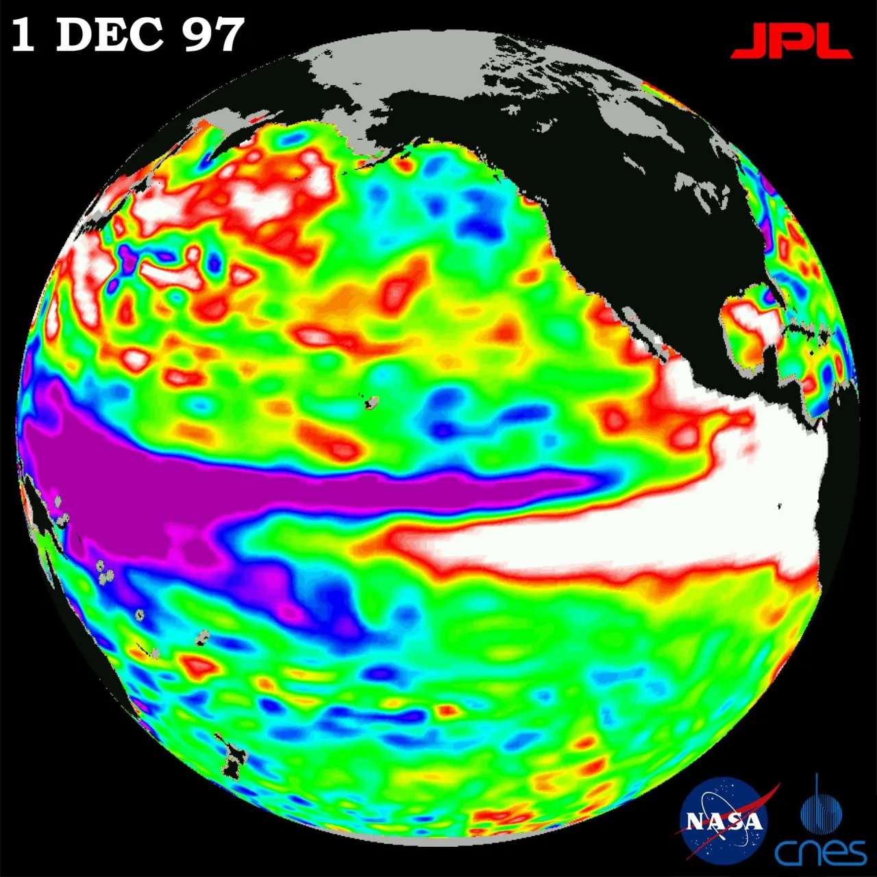
The World Meteorological Organization (WMO) has confirmed that El Niño is firmly established and will intensify into a very strong event, with significant impacts on rainfall and temperature patterns, increasing risks of floods, drought, and extreme heat.
According to the WMO, El Niño is characterized by exceptionally warm ocean conditions across the tropical Pacific, leading to changes in wind, pressure, and rainfall patterns around the world.
The European Union’s Copernicus Climate Change Service reported that August 2026 was the joint hottest month ever observed, tying with July 2023, as the most severe super El Niño on record amplified temperatures already heightened by global warming.
Samantha Burgess from Copernicus noted that humans have not experienced temperatures warmer than this summer in the past 100,000 years, highlighting the unprecedented nature of the current climate conditions.
The monthly mean temperature was 1.65°C above preindustrial levels, with the extra-polar ocean regions peaking at 21.1°C, the hottest temperature ever observed in the sea surface.
In the United States, the National Oceanic and Atmospheric Administration (NOAA) announced that this summer—from June to August—was the warmest in 132 years of record-keeping, with temperatures around the world unusually warm and surpassing several heat records.
The combination of record air temperatures, record ocean heat, and Europe's exceptional summer showed how climate change is now driving extremes across both the atmosphere and the oceans, according to experts.
El Niño's strength is measured by how far above normal sea surface temperatures are in a specific region of the Pacific, using a metric called the Niño 3.4 Relative Oceanic Niño Index (RONI).
El Niño's effects are widespread, with an active Pacific hurricane season, a hurricane-less Atlantic hurricane season, and Indonesia's overwhelming wildfires among the many consequences of this very strong El Niño.
What this adds
The report adds that the North Pacific jet stream has shifted southward due to sea surface temperature biases, affecting weather patterns further.
Background
A new study from the Center for American Progress highlights the widespread impact of violence on health and economic conditions in the United States, underscoring the need for comprehensive policy solutions.
Families of Brazilian prisoners spend an estimated $840 million a year on basic necessities for their incarcerated loved ones, according to a new study.
The Pacific Ocean is the largest and deepest of Earth's five oceanic divisions. It stretches from the Arctic Ocean in the north to the Southern Ocean, or, depending on the definition, to Antarctica in the south, and is bounded by the continents of Asia and Australia in the west and the Americas in the east.
What's confirmed
- The World Meteorological Organization (WMO) has confirmed that El Niño is firmly established and will intensify into a very strong event, with significant impacts on rainfall and temperature patterns, increasing risks of floods, drought, and extreme heat.
- According to the WMO, El Niño is characterized by exceptionally warm ocean conditions across the tropical Pacific, leading to changes in wind, pressure, and rainfall patterns around the world.
- The European Union’s Copernicus Climate Change Service reported that August 2026 was the joint hottest month ever observed, tying with July 2023, as the most severe super El Niño on record amplified temperatures already heightened by global warming.
- Samantha Burgess from Copernicus noted that humans have not experienced temperatures warmer than this summer in the past 100,000 years, highlighting the unprecedented nature of the current climate conditions.
- The monthly mean temperature was 1.65°C above preindustrial levels, with the extra-polar ocean regions peaking at 21.1°C, the hottest temperature ever observed in the sea surface.
- In the United States, the National Oceanic and Atmospheric Administration (NOAA) announced that this summer—from June to August—was the warmest in 132 years of record-keeping, with temperatures around the world unusually warm and surpassing several heat records.
- The combination of record air temperatures, record ocean heat, and Europe's exceptional summer showed how climate change is now driving extremes across both the atmosphere and the oceans, according to experts.
- El Niño's strength is measured by how far above normal sea surface temperatures are in a specific region of the Pacific, using a metric called the Niño 3.4 Relative Oceanic Niño Index (RONI).
- El Niño's effects are widespread, with an active Pacific hurricane season, a hurricane-less Atlantic hurricane season, and Indonesia's overwhelming wildfires among the many consequences of this very strong El Niño.
What's still developing
- See what temperatures and precipitation look like across the U.S.
- Meanwhile, most of the eastern United States and the Pacific Coast are expected to be cooler than average.
- Below average temperatures are forecast, along with an uptick in precipitation over traditional averages.
- September and October will be cooler and drier than average, with temperatures about 1°F below normal along with roughly 1 inch less rainfall than usual.
- Heat stored in the oceans is released into the atmosphere more gradually, contributing to higher global temperatures in the following year.
- That included unprecedented temperatures in the tropical Pacific, where winds have slackened and warm waters have been sloshing back toward the eastern Pacific, creating the strong El Niño. 5 graphs that show how the record-breaking El Niño will affect the world “August 2026 is remarkable not simply because it’s yet another temperature record that’s been broken but because multiple parts of the climate system have reached unprecedented levels at the same time,” she says.
- In light of the temperature record, the Energy and Climate Intelligence Unit (ECIU) – a UK-based think tank – called on leaders who will meet in November for the COP31 climate summit to both reverse the rise in greenhouse gas emissions and also invest more in adapting to the current impacts.
- El Niño is a natural climate pattern in which a band of the eastern Pacific turns unusually warm, releasing vast amounts of stored ocean heat into the atmosphere and nudging global temperatures upwards for around a year.
- One look at sea surface temperatures from this year compared to past record events shows just how much fossil fuel pollution has rewritten the rules.
- As a refresher: El Niño is characterized by warmer-than-average water temperatures along the equator in the Pacific Ocean.
- The warmer water triggers corresponding shifts in the atmosphere that have a domino effect on weather patterns around the globe.
- Related Reads Global temperatures on track to break 1.5°C but it's not too late to bring them back down, UN says In eastern and southern Africa, more than 162 million children are exposed to the impacts of this El Niño, like heat, droughts and flooding, according to Unicef.
Sources
- Almanaclink
- Newslink
- Newscientistlink
- BBClink
- Kcralink
- Thejournallink
- NPRlink
- WarpBeat — background on Study finds violence affects millions across US with links to health, economic hardship link
- WarpBeat — background on Brazilian Families Spend $840 Million Annually on Inmates, Study Finds link
- Wikipedia — background on Pacific Ocean link