
Home · World · Sep 6 archive
UN Votes 164-1 for Equal Earth Map, US Opposes
Confirmed
In Short: The United Nations General Assembly overwhelmingly adopted the Equal Earth map projection, while the United States was the sole dissenter.
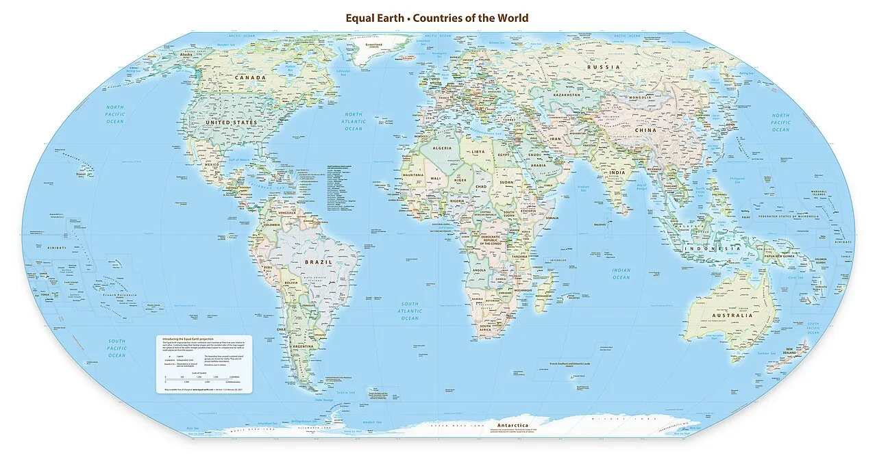
The United Nations General Assembly voted 164-1 in favor of adopting the Equal Earth map projection, a modern cartographic design that corrects the distortions of the centuries-old Mercator projection. The United States was the only nation to oppose the resolution, with Yaryna Ferencevych, the U.S. representative to the U.N., arguing that the vote was a distraction from more pressing global issues.
The Equal Earth map, created in 2018, accurately depicts the relative sizes of continents and countries, addressing the distortions present in the Mercator projection, which makes countries near the equator appear smaller and those near the poles larger. The map also distinguishes Crimea from mainland Ukraine, a point of contention for Ukraine, which abstained from the vote.
The resolution, titled 'Correct the Map,' encourages the use of equal-area projections like the Equal Earth map to improve the accuracy of cartographic representation. It aims to correct distortions that have historically minimized the global perception of regions like Africa, Latin America, and South Asia, and to promote cognitive justice.
What's confirmed
What's still developing
- In an effort to address this, a team of cartographers in 2018 created an equal area map they called the Equal Earth projection.
- Yaryna Ferencevych, the deputy U.S. representative to the United Nations Economic and Social Council, speaks against adopting the Equal Earth world map during the 114th plenary meeting of the 80th session of the U.N. General Assembly Sept. 4, 2026. (United Nations) "Instead of focusing on genuine problems of international peace, prosperity or good relations, this body is debating map projects from the 16th century and their role in promoting reparations and cognitive justice," Ferencevych said Friday during the 114th Plenary meeting.
- Ukraine abstained during a United Nations vote on the adoption of the Equal Earth world map projection after the depiction showed the temporarily occupied Crimean peninsula separated from the rest of Ukrainian territory, the Permanent Mission of Ukraine to the UN announced.
- Equal-area maps address this distortion by preserving the proportional size of continents and countries, although their shapes can appear somewhat different.
- The resolution states that the distortions “contribute to minimizing the extent of socioeconomic realities, infrastructure needs, development potential, and prosperity in the Southern regions, and that they can fuel prejudices in the environmental, geopolitical, and security fields.” The Equal Earth map was almost unanimously adopted by the member countries in the General Assembly.
- Bukayo Saka Scores in 59th Minute as Arsenal Beat Aston Villa 1-0 at Villa Park Libya Rivals Sign Tripoli Deal With UNSMIL to Hold National Elections Within Two Years The United Nations General Assembly voted on Friday to back a resolution titled “Correct the Map,” aimed at adopting the Equal Earth cartographic projection to correct distortions tied to the centuries-old Mercator projection.
- Al Jazeera reported that the resolution urged member states to adopt Equal Earth in place of the traditional Mercator projection, while also noting that the UN did not ban Mercator or impose a replacement.
- Al Jazeera reported that the UN said it is not banning Mercator or imposing a replacement, but is “merely encouraging the use of the Equal Earth projection,” leaving open how quickly platforms and institutions will adjust.